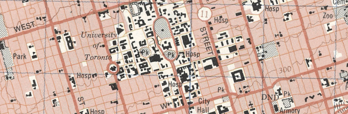
The University of Toronto Libraries (UTL) is pleased to announce the Historical National Topographic System (NTS): 1:50,000 Scale Maps, Data, & GIS, a new Open Access geospatial data collection of over 6000 Canadian maps that all researchers can discover, explore, and analyze.
This map series stretches across Canada and across time, covering the period of 1948 to today, providing an invaluable record of changes to the natural and human geography of the country. Digitization for a large portion of the series was recently completed by the McGill University Library and released as part of the online Canadiana collection. The current project builds on this series, transforming the maps into an open geospatial data resource available on the Borealis and Scholars GeoPortal platforms.
UTL, in partnership with McGill Libraries and with funding from Compute Ontario, are currently undertaking a mass-scale project to georeference the maps, a process that geographically positions the maps onto the Earth’s surface and creates geospatial data. Researchers can use the data in a variety of digital research tools, including geographic information systems (GIS), to analyze the maps. Access to historical GIS datasets based on national map series held in library collections supports transformation of physical maps into digital research data, enabling integration with current, real-world data for in-depth research and longitudinal analysis. This project builds on the commitment of academic libraries across the country to support access and preservation of these important historical maps and cultural resources.
“Map collections like these that map out an area over time and are georeferenced to overlay over current geographies, truly allow us to uncover and trace the land and its changing natural and human-made features, lost over time due to urban development,” says Marcel Fortin, Head, Map and Data Library, University of Toronto Libraries, who partners with and supports several Historical GIS projects including the Lost Rivers of Toronto and the "Changing the Narrative: Connecting Indigenous and Settler Histories at Black Creek Pioneer Village" projects. “It’s important to us that we can offer this data as an open resource, supporting researchers inside and outside of academia.”
“It’s great to see these old maps that were gathering dust in drawers have a new life. It has been a 10-year journey with partners across Canada, starting with cataloguers, then map librarians, and now connecting to projects like Borealis. It really has been a group effort,” adds Joseph Hafner, Associate Dean of Collection Services at McGill Library.
Kate Davis, Interim Director of Scholars Portal, says, “The Scholars GeoPortal is a platform built on the collaboration between Ontario’s university libraries, and we’re thrilled to be part of projects like this, which rely on the collaboration of libraries and library organizations across Canada. Today, the most popular collection on the GeoPortal is another set of historical topographic maps covering Ontario, previously digitized and georeferenced by OCUL. This broader, national collaboration adds an even larger series covering a wider geographic area and timespan to the GeoPortal’s collections. We look forward to continuing to strengthen the relationships we’ve made through this work.”
Over 6000 georeferenced maps and data are now available, including complete coverage for Ontario and over 3600 first edition maps for 100+ urban areas across Canada. Once completed, this collection will provide first edition maps Canada-wide, including the North, representing a total of over 15,800 maps and accompanying datasets. Researchers can search, discover, visualize, and explore, using the historical map search, map index, web map tiles, and dynamic mapping tools, for display in the OCUL Scholars GeoPortal platfor. Datasets are also stored and preserved in Borealis, the Canadian Dataverse Repository for persistent, long-term access.
Explore the NTS 1:50,000 maps in the Scholars GeoPortal
Search the collection on Borealis
For more information contact:topomaps@scholarsportal.info
About Scholars GeoPortal
Scholars GeoPortal is an award-winning geospatial data discovery tool, allowing Ontario’s university students and researchers of all disciplines to enrich their teaching and research with a single point of access and retrieval to a curated collection of maps and geospatial datasets. The GeoPortal is a service of the Ontario Council of University Libraries (OCUL), managed by Scholars Portal and hosted through the University of Toronto Libraries. Scholars Portal continues to respond to the research needs of Ontario universities through the creation of innovative information services and by working to ensure access to and preservation of this wealth of information.
About Borealis
Borealis is a bilingual, multi-disciplinary, secure, Canadian research data repository, supported by academic libraries and research institutions across Canada. Borealis supports discovery, management, sharing, and preservation of Canadian research data. The service is supported by the Digital Research Alliance of Canada and provided collaboratively through the University of Toronto Libraries, and participating regional library consortia: Bureau de Coopération Interuniversitaire (BCI), Council of Atlantic Academic Libraries (CAAL), Council of Prairie and Pacific University Libraries (COPPUL), and Ontario Council of University Libraries (OCUL).
About the University of Toronto Libraries
The University of Toronto Libraries (UTL) system is the largest academic library in Canada and is consistently ranked among the top-10 research libraries in North America. The system consists of 40 libraries located on three university campuses. The Libraries’ data centre houses nearly 600 virtual servers with a storage capacity of 3.3 petabytes.
About McGill University Library
The McGill University Library provides the comprehensive information infrastructure necessary to sustain leading-edge teaching, learning and research activity at McGill University. The Library holds more than seven million items in its various collections, which are located in numerous branches across McGill’s downtown and Macdonald campuses. Receiving over 5 million visits annually, and millions more visits online, it is an invaluable support system for the McGill community, with rich collections, wide-ranging information resources, innovative services and attractive, comfortable facilities.